Mbarara, Uganda (seismic) archived on April 18, 2018
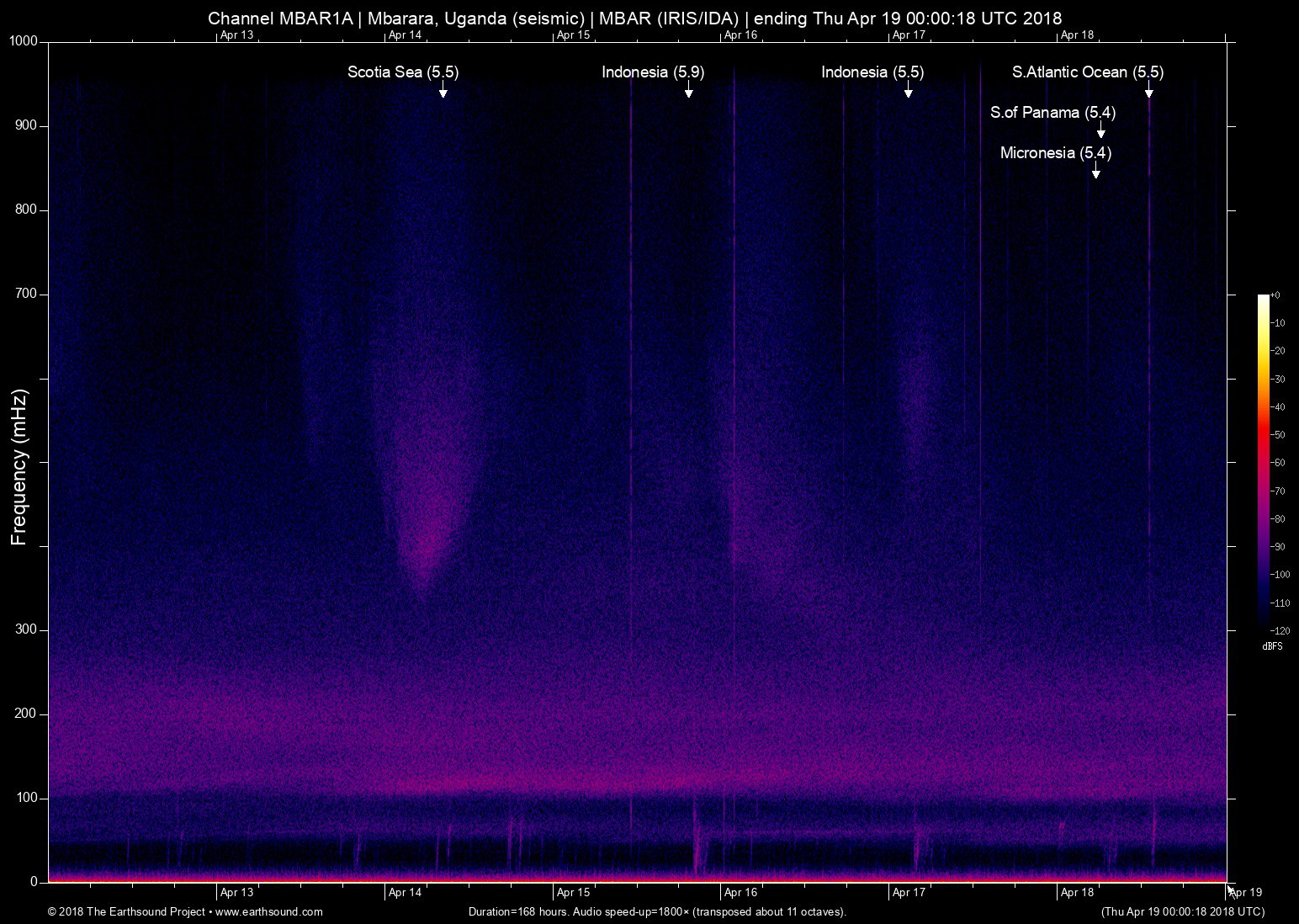
Annotated events during this period:
Time (UTC) Mag Lat Lon Depth Description
======================== === ====== ====== ===== ===========
Wed Apr 18 13:07:19 2018 5.5 -6.56 -0.38 6 S.Atlantic Ocean (South Atlantic Ocean)
Wed Apr 18 06:16:02 2018 5.4 -82.56 5.15 5 S.of Panama (South of Panama)
Wed Apr 18 05:32:01 2018 5.4 142.19 11.86 5 Micronesia (294km NE of Fais, Micronesia)
Tue Apr 17 02:52:35 2018 5.5 131.29 -3.53 6 Indonesia (265km E of Amahai, Indonesia)
Sun Apr 15 19:30:43 2018 5.9 126.87 1.37 6 Indonesia (85km NW of Kota Ternate, Indonesia)
Sat Apr 14 08:17:20 2018 5.5 -36.86 -61.39 6 Scotia Sea
Total: 6 events.
About this archived stream:
| Station : | MBAR (network: IRIS/IDA) at Mbarara, Uganda |
| Sensor : | Geotech KS54000 triaxial broadband borehole seismometer |
| Recorder : | Quanterra Q330 @ 100 Hz |
| Pod : | inanna@x.x.0.135 | macOS 10.12.6 | psm v. 126 |
| Speedup : | ×1,800 (transposed up about 11 octaves) |
| Loop duration (real) : | 168 hours |
| Loop duration (audio) : | 05:36 (stereo) |
| Data channels : | miniseed (II.MBAR.00.BH1 II.MBAR.00.BH2) |
| RMS : | 0.003187 |
| Spectrogram type : | raw |
| Gain correction : | 20dB |
| SoX post-processing : | highpass -2 90 highpass -2 90 compand 0.001,0.01 6:-80,-50,-40,-10,0,-3 |
| Archived on : | Thu Apr 19 00:00:18 UTC 2018 (about 9 years ago) |
| Metadata source : | auto-archived factoids |