Mbarara, Uganda (seismic) archived on October 16, 2018
Annotated events during this period:
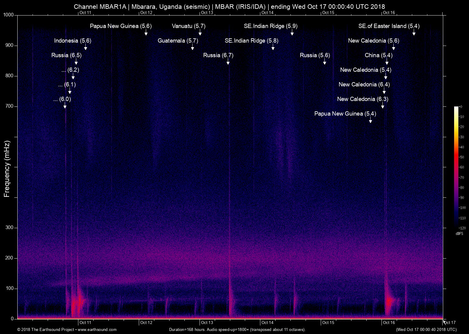
Time (UTC) Mag Lat Lon Depth Description
======================== === ====== ====== ===== ===========
Tue Oct 16 12:50:28 2018 5.4 -104.08 -35.53 5 SE.of Easter Island (Southeast of Easter Island)
Tue Oct 16 04:42:42 2018 5.6 169.43 -21.89 6 New Caledonia (164km ESE of Tadine, New Caledonia)
Tue Oct 16 02:10:13 2018 5.4 82.58 44.22 5 China (113km ENE of Yining Xian, China)
Tue Oct 16 01:38:25 2018 5.4 169.47 -21.80 5 New Caledonia (166km E of Tadine, New Caledonia)
Tue Oct 16 01:14:37 2018 5.8 169.37 -21.82 6 New Caledonia (156km E of Tadine, New Caledonia) *
Tue Oct 16 01:03:43 2018 6.4 169.49 -21.73 6 New Caledonia (167km E of Tadine, New Caledonia)
Tue Oct 16 00:28:12 2018 6.3 169.48 -21.94 6 New Caledonia (170km ESE of Tadine, New Caledonia)
Mon Oct 15 19:35:56 2018 5.4 151.24 -6.07 5 Papua New Guinea (134km ESE of Kimbe, Papua New Guinea)
Mon Oct 15 01:32:12 2018 5.6 159.46 54.06 6 Russia (121km NE of Yelizovo, Russia)
Sun Oct 14 12:41:14 2018 5.9 88.66 -42.30 6 SE.Indian Ridge (Southeast Indian Ridge)
Sun Oct 14 05:05:34 2018 5.8 88.54 -41.98 6 SE.Indian Ridge (Southeast Indian Ridge)
Sat Oct 13 11:10:23 2018 6.7 153.38 52.86 7 Russia (262km NW of Ozernovskiy, Russia)
Sat Oct 13 00:13:46 2018 5.7 167.22 -13.68 6 Vanuatu (42km WNW of Sola, Vanuatu)
Fri Oct 12 21:09:49 2018 5.7 -91.18 14.19 6 Guatemala (13km E of Nueva Concepcion, Guatemala)
Fri Oct 12 02:52:03 2018 5.6 151.05 -6.28 6 Papua New Guinea (128km SE of Kimbe, Papua New Guinea)
Thu Oct 11 02:55:45 2018 5.6 126.71 -5.03 6 Indonesia (139km S of Leksula, Indonesia)
Wed Oct 10 23:16:02 2018 6.5 156.21 49.35 6 Russia (148km S of Severo-Kuril'sk, Russia)
Wed Oct 10 22:00:35 2018 6.2 151.67 -4.96 6 Papua New Guinea (94km SW of Kokopo, Papua New Guinea)
Wed Oct 10 21:13:16 2018 5.9 151.14 -5.94 6 Papua New Guinea (117km ESE of Kimbe, Papua New Guinea) *
Wed Oct 10 20:59:01 2018 5.9 151.10 -5.91 6 Papua New Guinea (113km ESE of Kimbe, Papua New Guinea) *
Wed Oct 10 20:48:20 2018 7.0 151.20 -5.68 7 Papua New Guinea (117km E of Kimbe, Papua New Guinea) *
Wed Oct 10 20:45:26 2018 6.1 151.32 -5.75 6 Papua New Guinea (132km E of Kimbe, Papua New Guinea)
Wed Oct 10 18:44:55 2018 6.0 114.45 -7.46 6 Indonesia (39km NNE of Sumberanyar, Indonesia)
Wed Oct 10 02:03:00 2018 5.4 147.50 -6.17 5 Papua New Guinea (62km NW of Finschhafen, Papua New Guinea)
Total: 24 events; 4 not plotted (*).
About this archived stream:
| Station : | MBAR (network: IRIS/IDA) at Mbarara, Uganda |
| Sensor : | Geotech KS54000 triaxial broadband borehole seismometer |
| Recorder : | Quanterra Q330 @ 100 Hz |
| Pod : | inanna@x.x.0.135 | macOS 10.12.6 | psm v. 133 |
| Speedup : | ×1,800 (transposed up about 11 octaves) |
| Loop duration (real) : | 168 hours |
| Loop duration (audio) : | 05:36 (stereo) |
| Data channels : | miniseed (II.MBAR.00.BH1 II.MBAR.00.BH2) |
| RMS : | 0.003802 |
| Spectrogram type : | raw |
| Gain correction : | 20dB |
| SoX post-processing : | highpass -2 90 highpass -2 90 compand 0.001,0.01 6:-80,-50,-40,-10,0,-3 |
| Archived on : | Wed Oct 17 00:00:40 UTC 2018 (about 8 years ago) |
| Metadata source : | auto-archived factoids |