Mbarara, Uganda (seismic) archived on April 1, 2018
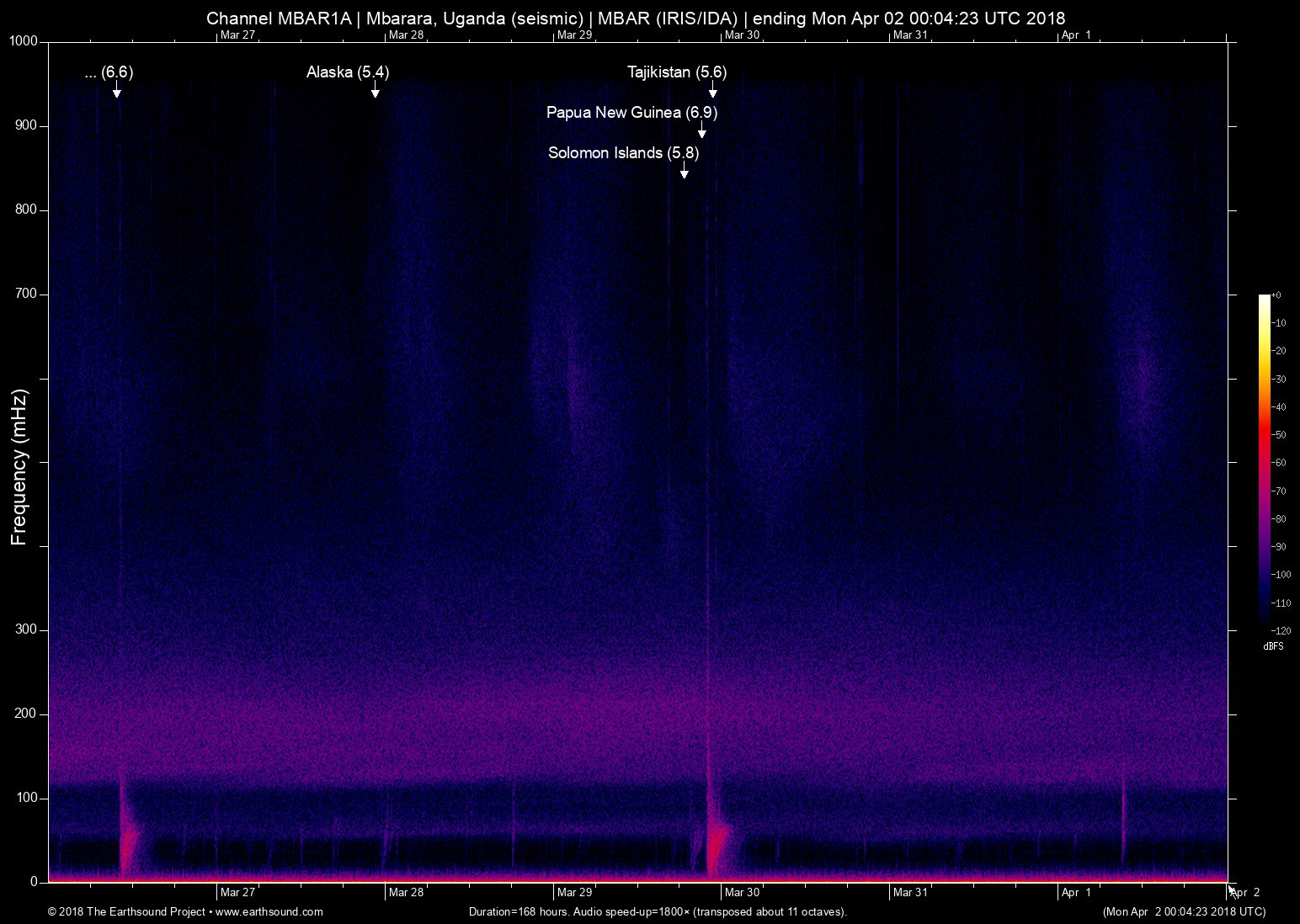
Annotated events during this period:
Time (UTC) Mag Lat Lon Depth Description
======================== === ====== ====== ===== ===========
Thu Mar 29 22:54:12 2018 5.6 69.95 38.74 6 Tajikistan (8km ESE of Roghun, Tajikistan)
Thu Mar 29 21:25:36 2018 6.9 151.44 -5.47 7 Papua New Guinea (144km E of Kimbe, Papua New Guinea)
Thu Mar 29 18:51:09 2018 5.8 159.56 -9.42 6 Solomon Islands (42km W of Honiara, Solomon Islands)
Tue Mar 27 22:41:08 2018 5.4 -148.60 56.53 5 Alaska (269km ESE of Kodiak, Alaska)
Mon Mar 26 09:51:00 2018 6.6 151.40 -5.46 7 Papua New Guinea (139km E of Kimbe, Papua New Guinea)
Total: 5 events.
About this archived stream:
| Station : | MBAR (network: IRIS/IDA) at Mbarara, Uganda |
| Sensor : | Geotech KS54000 triaxial broadband borehole seismometer |
| Recorder : | Quanterra Q330 @ 100 Hz |
| Pod : | inanna@x.x.0.135 | macOS 10.12.6 | psm v. 126 |
| Speedup : | ×1,800 (transposed up about 11 octaves) |
| Loop duration (real) : | 168 hours |
| Loop duration (audio) : | 05:36 (stereo) |
| Data channels : | miniseed (II.MBAR.00.BH1 II.MBAR.00.BH2) |
| RMS : | 0.003172 |
| Spectrogram type : | raw |
| Gain correction : | 20dB |
| SoX post-processing : | highpass -2 90 highpass -2 90 compand 0.001,0.01 6:-80,-50,-40,-10,0,-3 |
| Archived on : | Mon Apr 2 00:04:23 UTC 2018 (about 9 years ago) |
| Metadata source : | auto-archived factoids |